

SW Maps - GIS & Data Collector
SW Maps - GIS & Data Collector의 설명
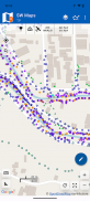
SW Maps는 지리 정보를 수집, 표시 및 공유하기 위한 무료 GIS 및 모바일 매핑 앱입니다.
고정밀 기기를 사용하여 전체 규모 GNSS 측량을 수행하든, 휴대폰만 사용하여 대량의 위치 기반 데이터를 수집해야 하든, 이동 중에 배경 지도 위에 레이블이 있는 몇 개의 셰이프파일을 보아야 하든 SW Maps는 다음과 같은 기능을 제공합니다. 다 다뤘습니다.
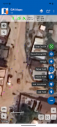
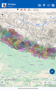
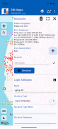
점, 선, 다각형, 사진까지 기록하고 선택한 배경 지도 위에 표시하고 사용자 정의 속성 데이터를 모든 지형지물에 첨부하세요. 속성 유형에는 텍스트, 숫자, 미리 정의된 선택 항목 집합의 옵션, 사진, 오디오 클립 및 비디오가 포함됩니다.
Bluetooth 또는 USB 직렬을 통해 외부 RTK 지원 수신기를 사용하여 고정밀 GPS 측량을 수행합니다.
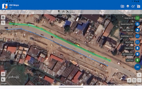
마커를 추가하여 지도에 지형지물을 그리고 거리와 면적을 측정합니다.
다른 설문조사를 위해 이전 프로젝트의 레이어와 속성을 재사용하거나 템플릿을 만들어 다른 사용자와 공유하세요.
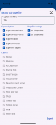
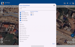
수집된 데이터를 Geopackage, KMZ 또는 Shapefile로 다른 사용자와 공유하거나 장치 저장소로 내보냅니다. 또한 기록된 데이터를 스프레드시트(XLS/ODS) 또는 CSV 파일로 공유하고 내보낼 수 있습니다.
특징
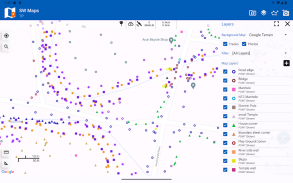
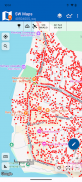
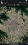
-온라인 기본 지도: Google 지도 또는 오픈 스트리트 지도
-여러 MB타일 및 KML 오버레이 지원
-속성 분류 스타일을 갖춘 Shapefile 레이어. PROJ.4 라이브러리가 지원하는 모든 좌표계에서 쉐이프파일을 봅니다.
-오프라인 사용을 위해 여러 온라인 WMTS, TMS, XYZ 또는 WMS 레이어와 캐시 타일을 추가합니다.
-RTK를 사용한 고정밀 측량을 위해 Bluetooth 또는 USB 직렬을 통해 외부 RTK GPS 수신기에 연결합니다. 또한 사후 처리를 위해 외부 수신기의 데이터를 기록합니다.
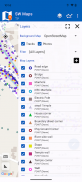
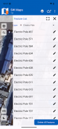
-각각 사용자 정의 속성 세트가 포함된 여러 개의 피처 레이어 정의
피처 유형: 점, 선, 다각형
속성 유형:텍스트, 숫자, 드롭다운 옵션, 체크리스트, 사진, 오디오, 비디오
재사용 또는 공유를 위해 템플릿으로 저장
-거리 측정과 함께 GPS 트랙 기록
-지도에 특징을 그리고 KMZ, Shapefiles, GeoJSON 또는 GeoPackages로 내보냅니다.
-속성 값을 기반으로 기능에 라벨을 붙입니다.
-템플릿이나 기존 프로젝트에서 피처 레이어를 가져옵니다.
-수집된 데이터를 KMZ(사진 포함), 모양 파일, GeoJSON, Geopackage(GPKG), XLS/ODS 스프레드시트 또는 csv 파일로 공유하거나 내보냅니다.
-다른 사용자와 템플릿 또는 프로젝트 공유
- 고정밀 GNSS 수신기를 사용하여 지상의 점과 선을 측설합니다.
이 제품은 네팔에서 제작되었으며 무료입니다(광고 없음). 이 내용이 유용하다고 생각되면 친구에게 네팔 제품을 사용했다는 사실을 알려주세요. 시간을 내어 이 멋진 나라를 방문하고 네팔 사람들을 알아보세요.
SW Maps - GIS & Data Collector - 버전 3.0.11.3
(05-03-2025)SW Maps - GIS & Data Collector - APK 정보
APK 버전: 3.0.11.3패키지: np.com.softwel.swmapsSW Maps - GIS & Data Collector의 최신 버전
다른 버전들


동일 카테고리의 앱